Friday, June 20
Dartmoor Dawdle:Monday June 16th
SNOWDON (GR 665 680)
453m
Snowdon? Surely a bit off track there Johnny?
That name took me aback a little as well when I spotted it on the OS map. But that's so typical of Dartmoor. An area so inadequately represented in outdoor writing in comparison to the reams of articles about routes around the Lakelands and Wales. But I'm getting ahead of myself. Here's the notes from my trip diary that I wrote up each evening. Mostly verbatim to give a flavour of the journey South to North on the eastern side of Dartmoor.
The train journey down to Ivybridge was largely uneventful. But with very tight train connections my plans for lunch were to be handled on my final leg out of Salisbury. However somewhere around Honiton when the buffet trolley finally rolled past my seat it was already cleared out of anything substantial. Hence the coffee, garlic flavoured olives and fruit cake pre-walk repast. Hardly the approved carb high preparation I’d had in mind. Shortly around 2pm, and within 15 minutes of leaving the train I was on the Two Moors Way, following the track northwards up onto the moorland proper. An initial compass bearing to pick the right well trodden path of three possible (so why is route finding always the most difficult near human habitation?) This quickly led onto the remains of the old tramway leading from Red Lake China Clay Works (GR 645 668) A wide and solid path, easy on the feet.

Possibly the simplest start to any wild land walk that I can recall. Route finding was largely unnecessary along this section. Just a case of following the very evident track.
After a few miles I paused to take-on water supplies at the first suitable spring I found, cutting across the track. An opportunity to try out my recently acquired water filter (but more on how that worked out in the round-up)
The check of the GPS showed that despite trying to take it steady on the initial ascent, I was already averaging around 3 mph. In fact the going was so easy that rather than camp up late in the afternoon as originally planned I decided to swing right at the MW stone (an easy marker to to miss in poor visibility by the way)
 (Two Moors Way Marker stone)
(But not before I'd walked alongside the longest stone row on Dartmoor, to the west of the track)
The going was now more like what I’d been expecting. Broken ground. Boggy in parts, and no obvious skyline targets to aim for. Map and compass work from hereon - using the circles of old settlements on the hillside opposite as my bearing point. A descent to Buckland Pool (GR 660 661) and across the stream to follow the north bank eastwards down to the remains of the old workings and the stone cross (Huntingdon Cross -GR 664 663) both features so typical and commonplace throughout my journey.
Turning north to follow Western Wella Brook back up to its source, I passed two wild campers tentatively tasting the water for its quality. Or more likely dead sheep. But as to how they could tell? Obviously some sensitive palates! Their pitch was well chosen on the first substantial section of flat land/good water flow that I’d come across in the valley.
As I worked my way up the valley my eye was looking for a suitable overnight spot, not too far from the water source. But opportunities were few with the ground so broken. This area was a typical flood plain with water running underground in places, but with signs that during times of high rainfall most of the landscape would be waterlogged. I came across a good track from the right leading to a bridge and onto the old mine (GR 666 672) - the first sign of a real path I’d spotted in the last hour. But with the weather remaining good I decided to keep heading towards the top of the valley assuming route finding would be difficult if on the following day visibility was poor.
Eventually the streams turned into trickles, spending more time underground than above, and the landscape remained obstinately broken until I finally spotted the only flat spot for probably miles around. And when the first tent peg hit rock I understood why this spot was so flat, and the grass so short. But with a bit of probing for peg purchase the Akto was up and the first brew on the evening in my hands. The wind continuing to gust down the valley, as it had most of the afternoon.
 (Wildcamp #1)
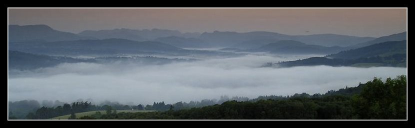
As I sit here supping I can see wild ponies on the far ridge. Sheep grazing the valley sides and then, incongruously, the sight of a hot air balloon appearing above the hills to the west for a few minutes before disappearing from view.
Already the feel of the Dartmoor landscape is coming to me. The OS map more of a topographical guide rather than a indicator of tracks to follow. My years spent following deer and pony tracks in the New Forest, often over waterlogged ground are proving so useful over this terrain where away from the main tracks route finding is a case of following sheep paths and reading the landscape ahead. Checking for the white flowering heads of Bog Myrtle warning of wet ground, and wary of any flat sections with large areas of moss across them.
Above the moon is rising in the clear sky - a cold one tonight I'd guess, despite the warmth earlier in the day.

453m
Snowdon? Surely a bit off track there Johnny?
That name took me aback a little as well when I spotted it on the OS map. But that's so typical of Dartmoor. An area so inadequately represented in outdoor writing in comparison to the reams of articles about routes around the Lakelands and Wales. But I'm getting ahead of myself. Here's the notes from my trip diary that I wrote up each evening. Mostly verbatim to give a flavour of the journey South to North on the eastern side of Dartmoor.
The train journey down to Ivybridge was largely uneventful. But with very tight train connections my plans for lunch were to be handled on my final leg out of Salisbury. However somewhere around Honiton when the buffet trolley finally rolled past my seat it was already cleared out of anything substantial. Hence the coffee, garlic flavoured olives and fruit cake pre-walk repast. Hardly the approved carb high preparation I’d had in mind. Shortly around 2pm, and within 15 minutes of leaving the train I was on the Two Moors Way, following the track northwards up onto the moorland proper. An initial compass bearing to pick the right well trodden path of three possible (so why is route finding always the most difficult near human habitation?) This quickly led onto the remains of the old tramway leading from Red Lake China Clay Works (GR 645 668) A wide and solid path, easy on the feet.

Possibly the simplest start to any wild land walk that I can recall. Route finding was largely unnecessary along this section. Just a case of following the very evident track.
After a few miles I paused to take-on water supplies at the first suitable spring I found, cutting across the track. An opportunity to try out my recently acquired water filter (but more on how that worked out in the round-up)
The check of the GPS showed that despite trying to take it steady on the initial ascent, I was already averaging around 3 mph. In fact the going was so easy that rather than camp up late in the afternoon as originally planned I decided to swing right at the MW stone (an easy marker to to miss in poor visibility by the way)
 (Two Moors Way Marker stone)
(But not before I'd walked alongside the longest stone row on Dartmoor, to the west of the track)
The going was now more like what I’d been expecting. Broken ground. Boggy in parts, and no obvious skyline targets to aim for. Map and compass work from hereon - using the circles of old settlements on the hillside opposite as my bearing point. A descent to Buckland Pool (GR 660 661) and across the stream to follow the north bank eastwards down to the remains of the old workings and the stone cross (Huntingdon Cross -GR 664 663) both features so typical and commonplace throughout my journey.
Turning north to follow Western Wella Brook back up to its source, I passed two wild campers tentatively tasting the water for its quality. Or more likely dead sheep. But as to how they could tell? Obviously some sensitive palates! Their pitch was well chosen on the first substantial section of flat land/good water flow that I’d come across in the valley.
As I worked my way up the valley my eye was looking for a suitable overnight spot, not too far from the water source. But opportunities were few with the ground so broken. This area was a typical flood plain with water running underground in places, but with signs that during times of high rainfall most of the landscape would be waterlogged. I came across a good track from the right leading to a bridge and onto the old mine (GR 666 672) - the first sign of a real path I’d spotted in the last hour. But with the weather remaining good I decided to keep heading towards the top of the valley assuming route finding would be difficult if on the following day visibility was poor.
Eventually the streams turned into trickles, spending more time underground than above, and the landscape remained obstinately broken until I finally spotted the only flat spot for probably miles around. And when the first tent peg hit rock I understood why this spot was so flat, and the grass so short. But with a bit of probing for peg purchase the Akto was up and the first brew on the evening in my hands. The wind continuing to gust down the valley, as it had most of the afternoon.
 (Wildcamp #1)
As I sit here supping I can see wild ponies on the far ridge. Sheep grazing the valley sides and then, incongruously, the sight of a hot air balloon appearing above the hills to the west for a few minutes before disappearing from view.
Already the feel of the Dartmoor landscape is coming to me. The OS map more of a topographical guide rather than a indicator of tracks to follow. My years spent following deer and pony tracks in the New Forest, often over waterlogged ground are proving so useful over this terrain where away from the main tracks route finding is a case of following sheep paths and reading the landscape ahead. Checking for the white flowering heads of Bog Myrtle warning of wet ground, and wary of any flat sections with large areas of moss across them.
Above the moon is rising in the clear sky - a cold one tonight I'd guess, despite the warmth earlier in the day.

All site material © John Hee - ask before you snatch


