Tuesday, May 1
Route planning; Toys, Tests & New Ideas
Oh how we boys do love our toys!
For my June Lakes trip I've been casting my eye over map, reference book and website to work out where to go; What to do.
Two nights of wildcamp are already sorted, as part of the UK Blogger meet-up.
These particular spots have been chosen for ease of access, relative quietness (besides a good chinwag!), views and prior knowledge of camp pitch & water availability. So nothing fancy on this score.
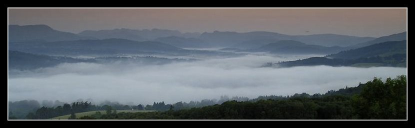
After all the site I chose for a solo camp isn't always one that will meet these criteria for a small number of tents. After a bank holiday evening at Styhead Tarn last year I realised whilst the company of like minded individuals can be good to have, I find it's good to have solitude as a balance. As this spot on Yoke shows from last year.

Whilst trying to find the blog link to this I realised that this trip was prior to starting the blog. As an idyllic trip (blazing sunshine/planned at a couple of days notice) perhaps it was one of the things that prompted me to start this site. I can even recall what I was doing as I took this snap; The memory is so sharp due to the location and timing; Anyway, more of that trip at a later date.......... back to the plot.
I've a few wildcamp spots already on my short list, but unfortunately they are spread rather too far apart for the time I have available. Initially I was looking at some very long days to join them together, but sanity is starting to prevail.
Why am I doing this trip? For the wildcamp; For the hills; For moving over new ground; So why force the pace at the cost of ruining the overall experience? And then there's the weather which can make or ruin an over ambitious trip.
Whatever tops I tick off as I pass are a bonus, but not a necessity. And as this is my first trip north this year, my hill fitness is low, so best to concentrate on a smaller area, possibly even hop a local bus to shorten distance between far apart spots. There's no disgrace in going for the Fun Factor.
Enter map reading & route assessment.
The coverage of my newly purchased Harvey Mountain Series 1:40,000 map is ideal. The only drawback, as I've already commented is the loss of detail compared to the OS 1:25,000 series.
After spending an hour with a second hand £10 flatbed scanner, bought for another use, and some free scan/picture edit software, I've managed to produce some stunningly detailed map sections for the more detailed areas I intend to visit. Trying to find an unnamed tarn on the top a crag with a reputation for cliffs is not something I intend to do without a good certainty of getting it RIGHT FIRST TIME. As a solo walker risk assessment is paramount. No second chances in this case.
A nice side benefit (and I'm talking to the over 40s now. Eyesight eh!) is the level of detail that suddenly leaps out from the scanned map image. I always use the small magnifier on the compass when out on the hill. At home I have a simple magnifying glass. But neither of these begins to approach the level of detail that zooming in on a pc screen can achieve. Stunning.
For instance - that spot pictured above was taken during a 30 hour period when I had only 3 litres of water available. For everything. The fells were in the middle of a serious heatwave. Most of the water sources were dry, or very very dubious.
Tonight, zooming in on the scanned map section immediately revealed a small number of streams, off both sides of the ridge, including a waterfall which would indicate a pretty good chance of a clean water supply. I'd not spotted that on the day, despite scouring the map. But it could have made a lot of difference, and prevented me having to spend the next day resting with the sole purpose of properly rehydrating.
I've considered mapping software to be an interesting toy, but rather too expensive for my use. I rely on maps when I'm out, and have never been happy to print off bits and pieces to take along. The 3D fly through facility has been tempting, but every time I've played with this, for a route I know, it seems over simplistic.
But now that I appear to be contradicting some of that approach, for the specific detail on this trip, I'm starting to question my stance.
If this zoom facility is an example of the level of simplified route planning for potential water sources perhaps it's tipping the balance for me?
I feel a calling coming on to revisit the latest mapping offerings and consider a possible purchase during this year. Something to play with on the next wet rest day in the Keswick/Ambleside outdoor emporiums.
Somehow I suspect I may have at least one of those coming up, despite the current run of early summer sunshine.Labels: Gear, Lake District
Comments:
Post a Comment
<< Home
For my June Lakes trip I've been casting my eye over map, reference book and website to work out where to go; What to do.
Two nights of wildcamp are already sorted, as part of the UK Blogger meet-up.
These particular spots have been chosen for ease of access, relative quietness (besides a good chinwag!), views and prior knowledge of camp pitch & water availability. So nothing fancy on this score.
After all the site I chose for a solo camp isn't always one that will meet these criteria for a small number of tents. After a bank holiday evening at Styhead Tarn last year I realised whilst the company of like minded individuals can be good to have, I find it's good to have solitude as a balance. As this spot on Yoke shows from last year.

Whilst trying to find the blog link to this I realised that this trip was prior to starting the blog. As an idyllic trip (blazing sunshine/planned at a couple of days notice) perhaps it was one of the things that prompted me to start this site. I can even recall what I was doing as I took this snap; The memory is so sharp due to the location and timing; Anyway, more of that trip at a later date.......... back to the plot.
I've a few wildcamp spots already on my short list, but unfortunately they are spread rather too far apart for the time I have available. Initially I was looking at some very long days to join them together, but sanity is starting to prevail.
Why am I doing this trip? For the wildcamp; For the hills; For moving over new ground; So why force the pace at the cost of ruining the overall experience? And then there's the weather which can make or ruin an over ambitious trip.
Whatever tops I tick off as I pass are a bonus, but not a necessity. And as this is my first trip north this year, my hill fitness is low, so best to concentrate on a smaller area, possibly even hop a local bus to shorten distance between far apart spots. There's no disgrace in going for the Fun Factor.
Enter map reading & route assessment.
The coverage of my newly purchased Harvey Mountain Series 1:40,000 map is ideal. The only drawback, as I've already commented is the loss of detail compared to the OS 1:25,000 series.
After spending an hour with a second hand £10 flatbed scanner, bought for another use, and some free scan/picture edit software, I've managed to produce some stunningly detailed map sections for the more detailed areas I intend to visit. Trying to find an unnamed tarn on the top a crag with a reputation for cliffs is not something I intend to do without a good certainty of getting it RIGHT FIRST TIME. As a solo walker risk assessment is paramount. No second chances in this case.
A nice side benefit (and I'm talking to the over 40s now. Eyesight eh!) is the level of detail that suddenly leaps out from the scanned map image. I always use the small magnifier on the compass when out on the hill. At home I have a simple magnifying glass. But neither of these begins to approach the level of detail that zooming in on a pc screen can achieve. Stunning.
For instance - that spot pictured above was taken during a 30 hour period when I had only 3 litres of water available. For everything. The fells were in the middle of a serious heatwave. Most of the water sources were dry, or very very dubious.
Tonight, zooming in on the scanned map section immediately revealed a small number of streams, off both sides of the ridge, including a waterfall which would indicate a pretty good chance of a clean water supply. I'd not spotted that on the day, despite scouring the map. But it could have made a lot of difference, and prevented me having to spend the next day resting with the sole purpose of properly rehydrating.
I've considered mapping software to be an interesting toy, but rather too expensive for my use. I rely on maps when I'm out, and have never been happy to print off bits and pieces to take along. The 3D fly through facility has been tempting, but every time I've played with this, for a route I know, it seems over simplistic.
But now that I appear to be contradicting some of that approach, for the specific detail on this trip, I'm starting to question my stance.
If this zoom facility is an example of the level of simplified route planning for potential water sources perhaps it's tipping the balance for me?
I feel a calling coming on to revisit the latest mapping offerings and consider a possible purchase during this year. Something to play with on the next wet rest day in the Keswick/Ambleside outdoor emporiums.
Somehow I suspect I may have at least one of those coming up, despite the current run of early summer sunshine.
Labels: Gear, Lake District

<< Home
All site material © John Hee - ask before you snatch


