
Monday, August 21
GPS - A place on the hills?

As I mentioned on a previous post (Aug 16) I'd planned to cover use of a GPS on the hills. This was largely as I've recently picked up a new GPS unit (Aug 19) and some of the old arguments for use v non-use came back to mind.
Better drag up a chair - this is going to be a long one
;-)
Working with new technology over too many decades now, the one thing I've come to be wary of is newness. It's too easy to grab at the latest gear without considering what improvement is offered, or even if it's actually useful.
For instance take adoption of 'bleeding edge' PCs. The latest fastest, and always the most expensive, has proved itself time and time again to be a costly exercise. I'm writing this on a 4 year old 1.8 GHz pc, running as quickly as many 6 month old models that I use at work. The key is appropriate use. My MS-Office may not be the latest version, but for my use it's perfect, and rather than relearn new packages I just carry on being productive. A newer hard drive every so often, a bit of fine-tuning on the operating system (now XP) and it delivers what I require.
I really don't need the latest stuff. The price just doesn't justify the marginal benefit I would get in return.
So what has this to do with GPS?
I tried out my first unit (Garmin Etrex) in 2001. This was largely as a result of using someone else's money to buy & test an early unit. I took it on a couple of short local outings, and despite marvelling at the technology packed into such a small box my feeling at that time was what was the benefit? Heavy(ish); Battery life not that great; Something else to lose when out and about?
At that time the majority of my walking was in areas where a map, compass and a good view would sort out 99% of route finding. Visibility was always near perfect, and I didn't have to cope with low cloud and lack of any visual clues.
Whilst intrigued with the way GPS registered my walking speed, averages and route there seemed to be little real benefit. Just another toy? So off it went to the walking club stock where members could borrow it when required.
Moving on a couple of years, with longer trips north, I'd occasionally borrow the unit mainly due to conversations with other people who were finding uses from their GPS. Some of the reasons still seemed largely pointless to me, but I was could appreciate the one real benefit that every GPS unit provides - the ability to mark the unit's location on the earth's surface, give or take a few meters. After all that's what it was invented for in the first place. The capability to show an OS Grid Reference (even if it was to 5 places -overkill?) became increasingly useful as a check to where I wanted to be.
Note - a check. Not a replacement for map & compass skills. Now my skills weren't that special at the time, but I knew enough to read a map and work out where I was, give or take a 1/2 mile or so.
I've never been lost. Just mislaid myself occasionally.
I could see some usefulness, but the cost was still way too high for the benefit (The price of technology will always rise from a more or less fixed bottom price, with new functionality driving the higher costs. Meanwhile the entry price remains the same. Ever wondered why you don't see £100 PCs?)
To recap - nice toy, Grid Ref great, but beyond that no desire to track my routes, or connect to a pc for up/downloads. Too expensive.
I kept an eye on the GPS market, as models became increasingly common place on the hills. But it wasn't until last year that I started to see the sort of unit I thought suitable.
At that time Garmin were exploring the running/fitness market and produced a wrist based unit. Small, light and with a specific use, rather than going for over functionality. Had they cracked it?
I had the chance to try early Foretrex & Forerunner models brought back to this country from the USA last year. Cost was about £60 when purchased in dollars. As a wrist mounted unit, both lightweight and compact with a small mono screen, it seemed to fit the bill. Only drawback - no Grid Ref, only latitude & longitude setting. Not much use to a wlaker, but moving in the right direction on weight and price.
Around this time I picked up on a thread about 'Which GPS to buy' on uk.rec.walking and during the conversation was introduced to the Garmin Geko, which was a budget level GPS. Hhhhmm - sounded interesting.
Smaller, quicker satellite lock-on (there the software has improved) less weight (AAA rather than AA battery) & at a price that compared favourably realtive to the 2001 prices.
On my next trip north a rainy day in Keswick found me playing with GPS models and Mapping Software over a route I'd just come down from. It was clear that here were converging technologies. The more expensive GPS models provided mapping on screen (at a cost) and the software allowed route preparation that could be converted from the visual into a format the GPS could show on the hills. And in turn the hill route could be fed back to the map for the route debrief that I do back home once the hard work is over (spots to come back to, or visit in future) A facit spotted by more than one walking web site to provide increasingly detailed trip reports, for which I am very grateful.
But despite being impressed by the software and its 3D fly thru of the route it still didn't feel quite right to me. Still too much work for my simple mind.
This helped clarify what I was looking for. Could I find a small, light GPS that handled Grid Ref but had some sort of expansion in case I ever did want to play further? Is so I was ready to buy if the price was right.
Recap No2. The unit was to support my existing route finding, and possibly provide further uses in the future. Not to replace a map & compass.
I set my limit at around £80, after all the Etrex was bought in 2001 for £100, a bargain at that time, but it was clear that the GPS software hadn't really moved that far in 5 years, for just the basic functions.
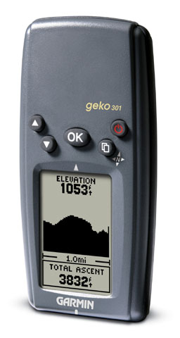
The Geko 101 (£80+) lacked pc connection, the 201 (£110+) and 301 (£150+) models had a pc link, the altimeter and electronic compass on the 301 making it the most expensive of the trio.
A quick Google search for the UK found a huge difference in prices, so off to E-Bay to see how cheap they could be.
The interesting point was that most of the E-Bay low tech units were either outdated bricks, or were being sold due to model upgrades. Looking at some of the items on offer I couldn't really see the reasoning behind that, most looked to be unused in the first place. Why upgrade? But more of that in a bit.
A week chasing 201 auctions, within my budget, brought nothing but I noticed that the 301 attracted less bids, probably for exactly the same reasons that led to me chasing the 201 myself. So I shifted viewpoint and bagged a hardly used 301 for £85 ( A bargain - current Argos price £189)
The unit is about the size of a small mobile phone, weighs less, and runs on 2 AAA batteries. The only useless function is the games on it (yes you read that correctly). Games? What bright spark in Garmin's marketing dept thought that one up!
And my experience since? I'd now prefer not to go on the hill without the 301 because it has become so useful. Not essential. Just my preference.
I have switched the auto-compass facility off (heavy battery use) but the altimeter means that alongside the Grid Ref, I have a reasonable elevation mark to help locate whereabouts on an ascent I am to save peering at the contour lines on the map (Apparently I can tell the weather with it as well, by use of the barometric pressure differential, but that involves further unit fiddling before setting off each day so let's leave that out for the present. Too much work and the weather will do what it will despite my GPS)
After each day's walking I now record my mileage/average speed and also the ascent/descent (never an issue before - after all I'd just walked it all) but it's somehow gratifying to see the day's journey marked out so clearly.
It's still a support tool for the map & compass, but a couple of times in thick cloud it's been a handy second opinion for my route finding, removing that element of doubt that can so easily discomfort me when travelling solo, my usual mode.
And therein lies the moral of this piece.
I'd bet 80% of GPS units bought for walking are never actually needed. Like the big name clothing they have become a fashion statement.
Mine is only ever used on trips over the fells across variable new ground. On a clear day I'll use it to record the journey, but the real work is still done with map & compass.
I've never pre loaded any routes, and I've no intention, at present, of spending my time loading the GPS tracks back to my pc. One - I refuse to pay the current £100 price for mapping software; Two - I mark my routes on the map as I go and that's all I need to avoid duplication in future.
Someday if I ever decide to create a web based journal of photos and routes, then might be the time to look at this further, but at present it seems a lot of time and energy that I could better use outdoors (says he writing a million word blog post!!)
As for colour screens, mapping and the such. If I wanted to watch a small screen, I'd stay at home and watch TV. On the hills every ounce I carry has a use and the GPS has proved it's worth in providing support for route assessments.
No more, no less.
So do GPS's have a place on the hill?
I'd say no, not if you have proficiency with map and compass and route finding is all that you require.
But if you fancy a safety blanket, or want to work further with your routes, there are now GPS models at a price that fits the bill.
Whether that need has been manufactured or not, is now really a redundant argument. GPS is here to stay.
Just make sure you but what you need, not what the manufacturers want to force on you.
(The same argument goes for mobile phones and similar new technologies I suspect)
(Postscript: Adding the Garmin links on this post I spotted the 101 model has now been discontinued. That explains why I bought it last week new for around £50. If you want one get in there quick here!)Labels: Gear
Comments:
I`ve a Garmin Etrex (Yellow) but really only ever use it for Geocaching.
Biggest problem with it, is to heavy and battery life is poor.
Also since having it, I haven't been anywhere were a GPS was needed :)
George:
Geocaching - damn I remembered there was something else that got me interested in GPS as a useful tool ;-)
I tried it a couple of times locally and it taught more about GPS navigation in a couple of hours than I'd learnt in days of walking.
Thanks for the memory jog - a subject for another post methinks.
And yes -the Etrex is a lump alongside the Geko. But it comes down to it's usefulness for you. It it feels like excess weight, best to leave it at home.
Sounds like you need a trip to the hills George before the weather turns too bad. After all you need to test your GPS out
;-)
I`ve a trip planned for the end of September, but not in the hills. I`m down in your neck on the woods on a 3 day backpacking trip, so I don't think the GPS will be needed :)
Goerge , if you fancy company one night on your trip, drop me an e-mail? Be nice to put a face to the name & we can compare b/packing notes
Post a Comment
<< Home
As I mentioned on a previous post (Aug 16) I'd planned to cover use of a GPS on the hills. This was largely as I've recently picked up a new GPS unit (Aug 19) and some of the old arguments for use v non-use came back to mind.
Better drag up a chair - this is going to be a long one
;-)
Working with new technology over too many decades now, the one thing I've come to be wary of is newness. It's too easy to grab at the latest gear without considering what improvement is offered, or even if it's actually useful.
For instance take adoption of 'bleeding edge' PCs. The latest fastest, and always the most expensive, has proved itself time and time again to be a costly exercise. I'm writing this on a 4 year old 1.8 GHz pc, running as quickly as many 6 month old models that I use at work. The key is appropriate use. My MS-Office may not be the latest version, but for my use it's perfect, and rather than relearn new packages I just carry on being productive. A newer hard drive every so often, a bit of fine-tuning on the operating system (now XP) and it delivers what I require.
I really don't need the latest stuff. The price just doesn't justify the marginal benefit I would get in return.
So what has this to do with GPS?
I tried out my first unit (Garmin Etrex) in 2001. This was largely as a result of using someone else's money to buy & test an early unit. I took it on a couple of short local outings, and despite marvelling at the technology packed into such a small box my feeling at that time was what was the benefit? Heavy(ish); Battery life not that great; Something else to lose when out and about?
At that time the majority of my walking was in areas where a map, compass and a good view would sort out 99% of route finding. Visibility was always near perfect, and I didn't have to cope with low cloud and lack of any visual clues.
Whilst intrigued with the way GPS registered my walking speed, averages and route there seemed to be little real benefit. Just another toy? So off it went to the walking club stock where members could borrow it when required.
Moving on a couple of years, with longer trips north, I'd occasionally borrow the unit mainly due to conversations with other people who were finding uses from their GPS. Some of the reasons still seemed largely pointless to me, but I was could appreciate the one real benefit that every GPS unit provides - the ability to mark the unit's location on the earth's surface, give or take a few meters. After all that's what it was invented for in the first place. The capability to show an OS Grid Reference (even if it was to 5 places -overkill?) became increasingly useful as a check to where I wanted to be.
Note - a check. Not a replacement for map & compass skills. Now my skills weren't that special at the time, but I knew enough to read a map and work out where I was, give or take a 1/2 mile or so.
I've never been lost. Just mislaid myself occasionally.
I could see some usefulness, but the cost was still way too high for the benefit (The price of technology will always rise from a more or less fixed bottom price, with new functionality driving the higher costs. Meanwhile the entry price remains the same. Ever wondered why you don't see £100 PCs?)
To recap - nice toy, Grid Ref great, but beyond that no desire to track my routes, or connect to a pc for up/downloads. Too expensive.
I kept an eye on the GPS market, as models became increasingly common place on the hills. But it wasn't until last year that I started to see the sort of unit I thought suitable.
At that time Garmin were exploring the running/fitness market and produced a wrist based unit. Small, light and with a specific use, rather than going for over functionality. Had they cracked it?
I had the chance to try early Foretrex & Forerunner models brought back to this country from the USA last year. Cost was about £60 when purchased in dollars. As a wrist mounted unit, both lightweight and compact with a small mono screen, it seemed to fit the bill. Only drawback - no Grid Ref, only latitude & longitude setting. Not much use to a wlaker, but moving in the right direction on weight and price.
Around this time I picked up on a thread about 'Which GPS to buy' on uk.rec.walking and during the conversation was introduced to the Garmin Geko, which was a budget level GPS. Hhhhmm - sounded interesting.
Smaller, quicker satellite lock-on (there the software has improved) less weight (AAA rather than AA battery) & at a price that compared favourably realtive to the 2001 prices.
On my next trip north a rainy day in Keswick found me playing with GPS models and Mapping Software over a route I'd just come down from. It was clear that here were converging technologies. The more expensive GPS models provided mapping on screen (at a cost) and the software allowed route preparation that could be converted from the visual into a format the GPS could show on the hills. And in turn the hill route could be fed back to the map for the route debrief that I do back home once the hard work is over (spots to come back to, or visit in future) A facit spotted by more than one walking web site to provide increasingly detailed trip reports, for which I am very grateful.
But despite being impressed by the software and its 3D fly thru of the route it still didn't feel quite right to me. Still too much work for my simple mind.
This helped clarify what I was looking for. Could I find a small, light GPS that handled Grid Ref but had some sort of expansion in case I ever did want to play further? Is so I was ready to buy if the price was right.
Recap No2. The unit was to support my existing route finding, and possibly provide further uses in the future. Not to replace a map & compass.
I set my limit at around £80, after all the Etrex was bought in 2001 for £100, a bargain at that time, but it was clear that the GPS software hadn't really moved that far in 5 years, for just the basic functions.
The Geko 101 (£80+) lacked pc connection, the 201 (£110+) and 301 (£150+) models had a pc link, the altimeter and electronic compass on the 301 making it the most expensive of the trio.
A quick Google search for the UK found a huge difference in prices, so off to E-Bay to see how cheap they could be.
The interesting point was that most of the E-Bay low tech units were either outdated bricks, or were being sold due to model upgrades. Looking at some of the items on offer I couldn't really see the reasoning behind that, most looked to be unused in the first place. Why upgrade? But more of that in a bit.
A week chasing 201 auctions, within my budget, brought nothing but I noticed that the 301 attracted less bids, probably for exactly the same reasons that led to me chasing the 201 myself. So I shifted viewpoint and bagged a hardly used 301 for £85 ( A bargain - current Argos price £189)
The unit is about the size of a small mobile phone, weighs less, and runs on 2 AAA batteries. The only useless function is the games on it (yes you read that correctly). Games? What bright spark in Garmin's marketing dept thought that one up!
And my experience since? I'd now prefer not to go on the hill without the 301 because it has become so useful. Not essential. Just my preference.
I have switched the auto-compass facility off (heavy battery use) but the altimeter means that alongside the Grid Ref, I have a reasonable elevation mark to help locate whereabouts on an ascent I am to save peering at the contour lines on the map (Apparently I can tell the weather with it as well, by use of the barometric pressure differential, but that involves further unit fiddling before setting off each day so let's leave that out for the present. Too much work and the weather will do what it will despite my GPS)
After each day's walking I now record my mileage/average speed and also the ascent/descent (never an issue before - after all I'd just walked it all) but it's somehow gratifying to see the day's journey marked out so clearly.
It's still a support tool for the map & compass, but a couple of times in thick cloud it's been a handy second opinion for my route finding, removing that element of doubt that can so easily discomfort me when travelling solo, my usual mode.
And therein lies the moral of this piece.
I'd bet 80% of GPS units bought for walking are never actually needed. Like the big name clothing they have become a fashion statement.
Mine is only ever used on trips over the fells across variable new ground. On a clear day I'll use it to record the journey, but the real work is still done with map & compass.
I've never pre loaded any routes, and I've no intention, at present, of spending my time loading the GPS tracks back to my pc. One - I refuse to pay the current £100 price for mapping software; Two - I mark my routes on the map as I go and that's all I need to avoid duplication in future.
Someday if I ever decide to create a web based journal of photos and routes, then might be the time to look at this further, but at present it seems a lot of time and energy that I could better use outdoors (says he writing a million word blog post!!)
As for colour screens, mapping and the such. If I wanted to watch a small screen, I'd stay at home and watch TV. On the hills every ounce I carry has a use and the GPS has proved it's worth in providing support for route assessments.
No more, no less.
So do GPS's have a place on the hill?
I'd say no, not if you have proficiency with map and compass and route finding is all that you require.
But if you fancy a safety blanket, or want to work further with your routes, there are now GPS models at a price that fits the bill.
Whether that need has been manufactured or not, is now really a redundant argument. GPS is here to stay.
Just make sure you but what you need, not what the manufacturers want to force on you.
(The same argument goes for mobile phones and similar new technologies I suspect)
(Postscript: Adding the Garmin links on this post I spotted the 101 model has now been discontinued. That explains why I bought it last week new for around £50. If you want one get in there quick here!)
Labels: Gear
I`ve a Garmin Etrex (Yellow) but really only ever use it for Geocaching.
Biggest problem with it, is to heavy and battery life is poor.
Also since having it, I haven't been anywhere were a GPS was needed :)
Biggest problem with it, is to heavy and battery life is poor.
Also since having it, I haven't been anywhere were a GPS was needed :)

George:
Geocaching - damn I remembered there was something else that got me interested in GPS as a useful tool ;-)
I tried it a couple of times locally and it taught more about GPS navigation in a couple of hours than I'd learnt in days of walking.
Thanks for the memory jog - a subject for another post methinks.
And yes -the Etrex is a lump alongside the Geko. But it comes down to it's usefulness for you. It it feels like excess weight, best to leave it at home.
Sounds like you need a trip to the hills George before the weather turns too bad. After all you need to test your GPS out
;-)
I`ve a trip planned for the end of September, but not in the hills. I`m down in your neck on the woods on a 3 day backpacking trip, so I don't think the GPS will be needed :)
Goerge , if you fancy company one night on your trip, drop me an e-mail? Be nice to put a face to the name & we can compare b/packing notes
Post a Comment
<< Home
All site material © John Hee - ask before you snatch


