Friday, April 6
Old ground re-covered
Waking to a persistent niggle in my lower back today's walk was always going to be little more than a meander in an attempt to stretch the problem out gradually. The sun and the general lack of wind indicated shirtsleeves, so that decided it for me.

I chose one of my summertime off-the-beaten-track routes around Dur Hill, to the west of the Bransgore to Burley road.
An attempt to steer clear of the bank holiday crowds. No desire today to stomp ahead, or break new ground, but more a deliberate intent to move onwards, stop as the fancy took me, and to get into the spirit of the moment.
To quote a common visitor on this site, W. H. Davies, 'What is this life if, full of care, we have no time to stand and stare?'
To accompany my meandering intent I loaded a small bum bag with camera, dictaphone and MP3 player/radio. Reminders to remain in an observational frame of mind by staying aware of photo opportunities, record any thoughts that arose as I wandered, and properly focus on some recent podcast material.
About the 4 Outdoor Show podcasts (or Podzines as they have been called)
Andy Howell's really starting to find his radio voice with these, after such a short apprenticeship.
Hilight for me was the interview with Harveys Maps (Podzine no2). Explaining how they create and design their maps, and the innovation that goes into the final product aimed at ease of use and an appropriateness to their environment/purchasers. It turned what could have been a boring sales pitch into a fascinating piece that wouldn't have been out of place on BBC Radio 4.
As a result the new 1:40000 Central Lake District map, jointly developed with BMC/UK Geologists is now high on my list of must buys.
Waterproof, designed to fold any which way you like, pretty indestructible. Sweet! And the first time I've ever heard the weight of a map quoted (90g)
I've not been a fan of Harveys in the past, probably because I was raised on the OS approach to reading map/landscape; The only one I've used was a strip map for the Cumbria Way, not the best trial I suspect. I have heard that it takes a while to retrain one's map interpretation to get the real benefit from Harvey design, so time for another attempt I think.
And I'd agree with Andy's comment about laminated maps. Great at home. Useless outdoors. Heavy, unwieldy, limited as to how they can be folded. Waterproof and durable definitely, but at a cost I find. Pity considering they were only laminated as an improvement for outdoor usage.

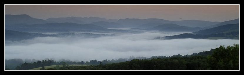
As I walked I took a variety of snaps and at one point it struck me how little frequented were some parts of the more trackless areas I passed.
Good views, even tree cover nearby. Possible wildcamp pitches as long as I carried in my water, and maintain a low profile?
I did come across this forest pony enjoying spring fodder, which explains why I don't rate the local water supply in this area.

Later I passed this well constructed shelter which I first spotted a couple of years ago, lying in the shadow of the main track above, mostly out of sight to the many passers by.
This was the first time I'd taken the time to have a closer poke around it (and only to get a better photo, so taking the camera achieved its aim)
Close-up its apparent that not only is it still being well maintained, but it has a second, better camouflaged neighbour
 I've no idea why these exist.
I had a theory when I first spotted it that the main one appeared around the time that forestry work was done in this area to remove the mature pines, but it may have just been revealed as the surrounding brush was removed.

Spot the hides?
I knew this spot quite well, regarding it as a little known suntrap at the right time of the year. And at the time of the forestry work I really felt that the beauty of this secret little place had been destroyed. But Mother Nature has quickly worked her magic and now there's a reasonable view down the valley and into the distance as the scrub is reasserting itself once more to cover the scarred heathland. So perhaps it will turn out not quite as bad as I'd originally feared.
So some more overnighter spots to consider. And with the amount of deer that frequent this area, quite a few bivvy spots for those dawn naturewatchs.
In the end the 3-4 mile walk over low hills and heathland took 2.5 hours, so that should give you some idea of my relaxed approach. A successful meander, showing that it's not necessarily the journey that's important, but the attitude of the person on the trip.
Not so much old ground re-covered, more new ground discovered. About myself. Labels: New Forest

I chose one of my summertime off-the-beaten-track routes around Dur Hill, to the west of the Bransgore to Burley road.
An attempt to steer clear of the bank holiday crowds. No desire today to stomp ahead, or break new ground, but more a deliberate intent to move onwards, stop as the fancy took me, and to get into the spirit of the moment.
To quote a common visitor on this site, W. H. Davies, 'What is this life if, full of care, we have no time to stand and stare?'
To accompany my meandering intent I loaded a small bum bag with camera, dictaphone and MP3 player/radio. Reminders to remain in an observational frame of mind by staying aware of photo opportunities, record any thoughts that arose as I wandered, and properly focus on some recent podcast material.
About the 4 Outdoor Show podcasts (or Podzines as they have been called)
Andy Howell's really starting to find his radio voice with these, after such a short apprenticeship.
Hilight for me was the interview with Harveys Maps (Podzine no2). Explaining how they create and design their maps, and the innovation that goes into the final product aimed at ease of use and an appropriateness to their environment/purchasers. It turned what could have been a boring sales pitch into a fascinating piece that wouldn't have been out of place on BBC Radio 4.
As a result the new 1:40000 Central Lake District map, jointly developed with BMC/UK Geologists is now high on my list of must buys.
Waterproof, designed to fold any which way you like, pretty indestructible. Sweet! And the first time I've ever heard the weight of a map quoted (90g)
I've not been a fan of Harveys in the past, probably because I was raised on the OS approach to reading map/landscape; The only one I've used was a strip map for the Cumbria Way, not the best trial I suspect. I have heard that it takes a while to retrain one's map interpretation to get the real benefit from Harvey design, so time for another attempt I think.
And I'd agree with Andy's comment about laminated maps. Great at home. Useless outdoors. Heavy, unwieldy, limited as to how they can be folded. Waterproof and durable definitely, but at a cost I find. Pity considering they were only laminated as an improvement for outdoor usage.

As I walked I took a variety of snaps and at one point it struck me how little frequented were some parts of the more trackless areas I passed.
Good views, even tree cover nearby. Possible wildcamp pitches as long as I carried in my water, and maintain a low profile?
I did come across this forest pony enjoying spring fodder, which explains why I don't rate the local water supply in this area.

Later I passed this well constructed shelter which I first spotted a couple of years ago, lying in the shadow of the main track above, mostly out of sight to the many passers by.
This was the first time I'd taken the time to have a closer poke around it (and only to get a better photo, so taking the camera achieved its aim)
Close-up its apparent that not only is it still being well maintained, but it has a second, better camouflaged neighbour
 I've no idea why these exist.
 I had a theory when I first spotted it that the main one appeared around the time that forestry work was done in this area to remove the mature pines, but it may have just been revealed as the surrounding brush was removed.

Spot the hides?
I knew this spot quite well, regarding it as a little known suntrap at the right time of the year. And at the time of the forestry work I really felt that the beauty of this secret little place had been destroyed. But Mother Nature has quickly worked her magic and now there's a reasonable view down the valley and into the distance as the scrub is reasserting itself once more to cover the scarred heathland. So perhaps it will turn out not quite as bad as I'd originally feared.
So some more overnighter spots to consider. And with the amount of deer that frequent this area, quite a few bivvy spots for those dawn naturewatchs.
In the end the 3-4 mile walk over low hills and heathland took 2.5 hours, so that should give you some idea of my relaxed approach. A successful meander, showing that it's not necessarily the journey that's important, but the attitude of the person on the trip.
Not so much old ground re-covered, more new ground discovered. About myself.
Labels: New Forest
All site material © John Hee - ask before you snatch


