Thursday, May 21
Lake District: 3 Tarns Wildcamp: Sun May 17th
The previous evening I'd worked out that by missing out the central Lakeland wildcamps I’d solved my original transport problem of gettting from Grasmere to Troutbeck for my second objective on this trip.
Back home, pouring over the map and bus timetables the obvious solution was to hop from Grasmere to Windermere and pick up the weekend only 519 service to Kentmere. That was until I looked for a bus timetable - the service was listed on the Cumbria bus routemap, but it had ceased. A quick post on Outdoors Magic had confirmed a general lack of alternatives.
It seemed the only options were a long walk between two points covering old ground & a new section with little attraction; Or hop a taxi.
Neither solution felt right. So the decision to pick up the limited weekend 517 service in Patterdale solved this quickly moving along the Kirkstone Pass, down to Troutbeck. Only draw back -the service runs three times a day, so missing the connection meant a very long roadside wait. Or hope that some kindly Sunday driver would take pity on a rather smelly backpacker, roadside with a thumb aloft looking for a ride.
With a deadline to hit I was awake early for the haul down the valley to Patterdale. Some of the stronger wind gusts overnight had at times threatened to flatten the tent. But the Akto, as ever, took it all and bounced right back.
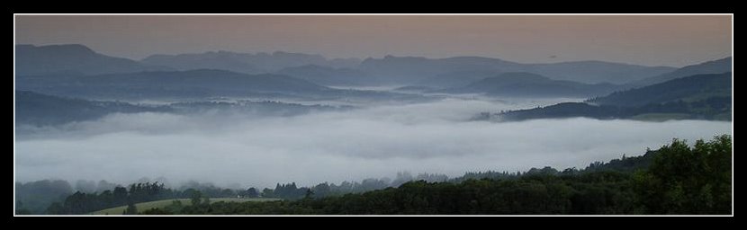
Opening the flysheet I was surprised to be met by a wonderfully clear and sunny morning. Over a brew and quick breakfast I sat on a warm boulder watching as two birds buzz bombed a weasel working its way around the boulders. Oblivious to my presence, I spent 10 minutes in their company. The weasel busily looking for its own breakfast; The birds most insistent that it wouldn’t involve them or their prodigy. Even in the remotest area nature reminds that the human is the interloper, as the natural world appears from hiding to continue the daily battle of survival in high places.
But little time to tarry if I was to catch that bus. If I thought the ascent the previous day had been hard work the descent over rough ground on cold leg muscles was about as bad. Especially with a necessary wariness of sliding on the steeper sections, grass wet from morning dew.
 (Half way down)
 (or half way up?)
By the time I'd finally returned to the Outward Bound hut my thigh muscles were burning, and my achilles tendon injury, courtesy of the Dartmoor April trip, had started to make its presence felt again.
The path into Patterdale was deserted at this time of the early morning, save for the usual sheep and a quick glimpse of deer deep inside pathside woodland. The wind had dropped, but I was sticking with the Paramo, side vents unzipped, sleeves rolled up, keeping the still present wind from cooling me down.
My timing was good. Just long enough to sort out my kit, grab a quick snack and then hop aboard the bus. At the next stop a couple of fellow wildcampers got on, after a night at Brothers Water they'd similarly found the wind troublesome. As the bus passed the Kirkstone Inn I sat with the map in my lap trying to spot some tracks on the far fellside in the hope I could make the afternoon route a more direct ascent, rather than meander up the Troutbeck valley northwards, only to then turn southwards and walk back towards tonight's objective.
A couple of likely options were just falling into place, when I realised the bus driver had passed straight though Troutbeck village, and out the other side.
Happily he stopped when asked. Unhappily I was now a couple of miles beyond my intended start point and looking at a road walk back to the village before I even got started on the real meat of the day.
Bugger. More replanning. Again. Seems this trip was turning into a test of adaptability.
The last time I descended Garburn Road I was badly dehydrated after a long ridge walk the previous day from Patterdale in a heat wave. I'd wildcamped at the edge of the ridge (GR: 436 061) near Yoke eking out 3 litres of water over 30+ hours. I recalled the Garburn Road descent as a waterless & foot bashing slog. The track was rockily uneven along much of its length. A place where any lack of concentration could result in a bad stumble & possible injury. I really didn’t fancy repeating that. But it looked like the nearby Longmire Road (GR: 414 013) leading onto Garburn Pass was the most obvious option.
In the event the track wasn't as bad as I remembered it, with signs that some remedial work had been done to reduce the more troublesome sections. As I climbed the clouds moved back in from behind me, rain holding off but the wind once again starting to build. Worryingly it was coming in from the east, and the crag I was heading for had scant protection only on the west side.
The fellside track leading from Garburn Road onto Yoke was still under construction last time I passed through. I remember sitting high on the ridge, warm in just a pair of shorts, listening to the radio coverage as England departed the 2006 World Cup. Below a digger work late into the evening, the driver similarly intent it seemed on listening to the game. For when it finished he stopped, jumped aboard a quad bike and rode off leaving the fellside finally silent as the sound of the bike disappeared down into the valley far below.
Now, three years later, the boggier parts, despite intense rainfall, had been mostly averted and the track surface was smooth enough to attract the attention of a number of mountain bikers descending at speed as I walked in the opposite way. Time has turned the then ravaged fell into a more natural track. Although its wide and strident mark across the fell remains uncharacteristic and at times an ugly feature.
It was during that 2006 trip, moving southwards over Ill Bell (GR: 436 077), that I'd first spotted my tarn.
 (Sunnier days)
On that hot day it had glittered in the bright sunshine. In the distant heat haze it seemed a beckoning jewel laying along the remote crag. I'd had a cursory look for it later that day, but to no avail. Back home I’d spent some time tracking it down, unnamed as it is on the OS map. During my research I'd found very few pictures of the tarn; But several warnings about its difficult position high on an exposed crag.
Even my usually reliable reference works didn't mention this water (For those interested - Heaton-Cooper 'The Tarns of Lakeland';Don Blair- 'Exploring Lakeland Tarns')
[So baring any earlier claims I name this place Rainsborrow Tarn (GR: 443 068); But I won't be claiming squatter's rights just yet!]
I sheltered behind the fell wall, by the newly constructed stile before making the final steep ascent onto Yoke.
By now the buffeting wind was making progress difficult at times. Mentally I was already considering a quick visit to the Tarn, a restock on water, and then a sheltered wildcamp pitch on the western slope of Yoke. If there was one to be found. But I was also aware that if there was any overnight wind shift the western slope could be as exposed.
At Yoke's cairn I picked up a small track to the right, descending eastwards on a compass and grid bearing. The slope of the hill hid any of the features further below.
Finally I spotted a line of old fence posts, leading in turn to the remains of a stone wall, and beyond it - the tarn itself.
 (Rainsborrow Tarn)
As I crossed over the wall I was already on the lookout for any sheltered pitches from the wind's increasing force. A couple of possibilities were lined up, but the surrounding ground, broken and peat bogged, suggested an area liable to flooding from the slopes above in heavy rainfall.
Perhaps the tarn would have something better - or would a strategic withdrawal be safer?
A quandry.
The immediate area around the tarn, whilst not under water, was clearly water logged. Sphagnum moss squelched as I moved over it. A few metres to the south of the tarn a shallow lip on a ridge below held a couple of smaller water pools, but in a truly exposed area.
 (Here comes the rain)
A quick circuit of the small water gave a couple of possibilities. A repeat exploration, with me hunkering down at tent height, confirmed that whilst not perfect, they offered reasonable wind shelter. Final selection - a spot in a dip. Not the by-the-book sort of camp spot, but with low shelter on three sides and the fourth open to the tarn, but directly in line with a large rock outcrop beyond, this seemed not only suitable, but actually felt better protected than the fellwall I'd hidden behind at the foot of Yoke.
 (Rainsborrow Tarn wildcamp)
Tent quickly up. Brew on. And then the rain hit. With a vengeance. Still only mid afternoon.
I spent the next few hours zipped comfortably inside the Akto, dry (for a change) and supping various brews and food. During a respite I took another turn around the area, hunting for a mobile phone signal to check in at home.
The crag was surrounded on three sides by steepish drops, the one behind the tent a plunge of a couple of hundred metres down to the old quarry workings above Kentmere Reservoir.
 (Kentmere Reservoir)
Despite the wind, rain & campsite concerns for once it looked like I’d finally beaten the weather. Dry and warm inside the tent.
Based on the weather to date, and the forecast for the next few days, there was little to be gained from staying out any longer. I’d visited both my main interests on this trip - Hard Tarn and Rainsborrow Tarn. Time to call an end.
I called Ambleside YHA to book a bed for the following night only to be met by a new auto-telephone system. The wind howled around me as I partly sheltered behind a convenient rock. Partly? Well any movement lost the mobile signal which despite the occasional view far off to the Welsh coast (I think) was wandering all over the place.
'Press button 1' etc etc. Finally - the booking service.
But no.
'Please leave a message and we'll get back to you within 24 hours; Or book on-line at www.yha….'
Great. Just what I needed as I hid away from the increasing wind-chill behind a rock high on a wind blasted crag. I explained my need, and the possible difficulty in 'getting back to me'. A text message would be preferable please.
(I'm still waiting for a response of any sort 4 days later)
Plan B- a quick call home to book via the web. God it was never this difficult in the past!
Back inside the tent the temperature was reading 7 deg C. But the humidity meant I could see each breath.
Time for warmth. I slipped inside by sleeping bag, ready for bed despite it not yet being 7pm.
And I do this for pleasure?
Hmm.Labels: Lake District
Comments:
Too late with Rainsborrow Tarn, see our Kentmere Fells trip. Actually now I remember that the name came from The Nuttalls books on the Tarns of Lakeland derived from Rainsborrow Crag. I remember thinking at the time that it might make an excellent pitch provided the wind wasn't a problem, it's a really exposed spot and when we were there it was a sheet of ice.
Adaptability was the buzzword on that day, you did well there especially with the vagaries of the buses and YHA to contend with, very hit-and-miss for my liking. Sometimes it's best to call it a day.
Post a Comment
<< Home
Back home, pouring over the map and bus timetables the obvious solution was to hop from Grasmere to Windermere and pick up the weekend only 519 service to Kentmere. That was until I looked for a bus timetable - the service was listed on the Cumbria bus routemap, but it had ceased. A quick post on Outdoors Magic had confirmed a general lack of alternatives.
It seemed the only options were a long walk between two points covering old ground & a new section with little attraction; Or hop a taxi.
Neither solution felt right. So the decision to pick up the limited weekend 517 service in Patterdale solved this quickly moving along the Kirkstone Pass, down to Troutbeck. Only draw back -the service runs three times a day, so missing the connection meant a very long roadside wait. Or hope that some kindly Sunday driver would take pity on a rather smelly backpacker, roadside with a thumb aloft looking for a ride.
With a deadline to hit I was awake early for the haul down the valley to Patterdale. Some of the stronger wind gusts overnight had at times threatened to flatten the tent. But the Akto, as ever, took it all and bounced right back.
Opening the flysheet I was surprised to be met by a wonderfully clear and sunny morning. Over a brew and quick breakfast I sat on a warm boulder watching as two birds buzz bombed a weasel working its way around the boulders. Oblivious to my presence, I spent 10 minutes in their company. The weasel busily looking for its own breakfast; The birds most insistent that it wouldn’t involve them or their prodigy. Even in the remotest area nature reminds that the human is the interloper, as the natural world appears from hiding to continue the daily battle of survival in high places.
But little time to tarry if I was to catch that bus. If I thought the ascent the previous day had been hard work the descent over rough ground on cold leg muscles was about as bad. Especially with a necessary wariness of sliding on the steeper sections, grass wet from morning dew.
 (Half way down)
 (or half way up?)
By the time I'd finally returned to the Outward Bound hut my thigh muscles were burning, and my achilles tendon injury, courtesy of the Dartmoor April trip, had started to make its presence felt again.
The path into Patterdale was deserted at this time of the early morning, save for the usual sheep and a quick glimpse of deer deep inside pathside woodland. The wind had dropped, but I was sticking with the Paramo, side vents unzipped, sleeves rolled up, keeping the still present wind from cooling me down.
My timing was good. Just long enough to sort out my kit, grab a quick snack and then hop aboard the bus. At the next stop a couple of fellow wildcampers got on, after a night at Brothers Water they'd similarly found the wind troublesome. As the bus passed the Kirkstone Inn I sat with the map in my lap trying to spot some tracks on the far fellside in the hope I could make the afternoon route a more direct ascent, rather than meander up the Troutbeck valley northwards, only to then turn southwards and walk back towards tonight's objective.
A couple of likely options were just falling into place, when I realised the bus driver had passed straight though Troutbeck village, and out the other side.
Happily he stopped when asked. Unhappily I was now a couple of miles beyond my intended start point and looking at a road walk back to the village before I even got started on the real meat of the day.
Bugger. More replanning. Again. Seems this trip was turning into a test of adaptability.
The last time I descended Garburn Road I was badly dehydrated after a long ridge walk the previous day from Patterdale in a heat wave. I'd wildcamped at the edge of the ridge (GR: 436 061) near Yoke eking out 3 litres of water over 30+ hours. I recalled the Garburn Road descent as a waterless & foot bashing slog. The track was rockily uneven along much of its length. A place where any lack of concentration could result in a bad stumble & possible injury. I really didn’t fancy repeating that. But it looked like the nearby Longmire Road (GR: 414 013) leading onto Garburn Pass was the most obvious option.
In the event the track wasn't as bad as I remembered it, with signs that some remedial work had been done to reduce the more troublesome sections. As I climbed the clouds moved back in from behind me, rain holding off but the wind once again starting to build. Worryingly it was coming in from the east, and the crag I was heading for had scant protection only on the west side.
The fellside track leading from Garburn Road onto Yoke was still under construction last time I passed through. I remember sitting high on the ridge, warm in just a pair of shorts, listening to the radio coverage as England departed the 2006 World Cup. Below a digger work late into the evening, the driver similarly intent it seemed on listening to the game. For when it finished he stopped, jumped aboard a quad bike and rode off leaving the fellside finally silent as the sound of the bike disappeared down into the valley far below.
Now, three years later, the boggier parts, despite intense rainfall, had been mostly averted and the track surface was smooth enough to attract the attention of a number of mountain bikers descending at speed as I walked in the opposite way. Time has turned the then ravaged fell into a more natural track. Although its wide and strident mark across the fell remains uncharacteristic and at times an ugly feature.
It was during that 2006 trip, moving southwards over Ill Bell (GR: 436 077), that I'd first spotted my tarn.
 (Sunnier days)
On that hot day it had glittered in the bright sunshine. In the distant heat haze it seemed a beckoning jewel laying along the remote crag. I'd had a cursory look for it later that day, but to no avail. Back home I’d spent some time tracking it down, unnamed as it is on the OS map. During my research I'd found very few pictures of the tarn; But several warnings about its difficult position high on an exposed crag.
Even my usually reliable reference works didn't mention this water (For those interested - Heaton-Cooper 'The Tarns of Lakeland';Don Blair- 'Exploring Lakeland Tarns')
[So baring any earlier claims I name this place Rainsborrow Tarn (GR: 443 068); But I won't be claiming squatter's rights just yet!]
I sheltered behind the fell wall, by the newly constructed stile before making the final steep ascent onto Yoke.
By now the buffeting wind was making progress difficult at times. Mentally I was already considering a quick visit to the Tarn, a restock on water, and then a sheltered wildcamp pitch on the western slope of Yoke. If there was one to be found. But I was also aware that if there was any overnight wind shift the western slope could be as exposed.
At Yoke's cairn I picked up a small track to the right, descending eastwards on a compass and grid bearing. The slope of the hill hid any of the features further below.
Finally I spotted a line of old fence posts, leading in turn to the remains of a stone wall, and beyond it - the tarn itself.
 (Rainsborrow Tarn)
As I crossed over the wall I was already on the lookout for any sheltered pitches from the wind's increasing force. A couple of possibilities were lined up, but the surrounding ground, broken and peat bogged, suggested an area liable to flooding from the slopes above in heavy rainfall.
Perhaps the tarn would have something better - or would a strategic withdrawal be safer?
A quandry.
The immediate area around the tarn, whilst not under water, was clearly water logged. Sphagnum moss squelched as I moved over it. A few metres to the south of the tarn a shallow lip on a ridge below held a couple of smaller water pools, but in a truly exposed area.
 (Here comes the rain)
A quick circuit of the small water gave a couple of possibilities. A repeat exploration, with me hunkering down at tent height, confirmed that whilst not perfect, they offered reasonable wind shelter. Final selection - a spot in a dip. Not the by-the-book sort of camp spot, but with low shelter on three sides and the fourth open to the tarn, but directly in line with a large rock outcrop beyond, this seemed not only suitable, but actually felt better protected than the fellwall I'd hidden behind at the foot of Yoke.
 (Rainsborrow Tarn wildcamp)
Tent quickly up. Brew on. And then the rain hit. With a vengeance. Still only mid afternoon.
I spent the next few hours zipped comfortably inside the Akto, dry (for a change) and supping various brews and food. During a respite I took another turn around the area, hunting for a mobile phone signal to check in at home.
The crag was surrounded on three sides by steepish drops, the one behind the tent a plunge of a couple of hundred metres down to the old quarry workings above Kentmere Reservoir.
 (Kentmere Reservoir)
Despite the wind, rain & campsite concerns for once it looked like I’d finally beaten the weather. Dry and warm inside the tent.
Based on the weather to date, and the forecast for the next few days, there was little to be gained from staying out any longer. I’d visited both my main interests on this trip - Hard Tarn and Rainsborrow Tarn. Time to call an end.
I called Ambleside YHA to book a bed for the following night only to be met by a new auto-telephone system. The wind howled around me as I partly sheltered behind a convenient rock. Partly? Well any movement lost the mobile signal which despite the occasional view far off to the Welsh coast (I think) was wandering all over the place.
'Press button 1' etc etc. Finally - the booking service.
But no.
'Please leave a message and we'll get back to you within 24 hours; Or book on-line at www.yha….'
Great. Just what I needed as I hid away from the increasing wind-chill behind a rock high on a wind blasted crag. I explained my need, and the possible difficulty in 'getting back to me'. A text message would be preferable please.
(I'm still waiting for a response of any sort 4 days later)
Plan B- a quick call home to book via the web. God it was never this difficult in the past!
Back inside the tent the temperature was reading 7 deg C. But the humidity meant I could see each breath.
Time for warmth. I slipped inside by sleeping bag, ready for bed despite it not yet being 7pm.
And I do this for pleasure?
Hmm.
Labels: Lake District
Too late with Rainsborrow Tarn, see our Kentmere Fells trip. Actually now I remember that the name came from The Nuttalls books on the Tarns of Lakeland derived from Rainsborrow Crag. I remember thinking at the time that it might make an excellent pitch provided the wind wasn't a problem, it's a really exposed spot and when we were there it was a sheet of ice.
Adaptability was the buzzword on that day, you did well there especially with the vagaries of the buses and YHA to contend with, very hit-and-miss for my liking. Sometimes it's best to call it a day.
Post a Comment
Adaptability was the buzzword on that day, you did well there especially with the vagaries of the buses and YHA to contend with, very hit-and-miss for my liking. Sometimes it's best to call it a day.


<< Home
All site material © John Hee - ask before you snatch


