Saturday, April 25
Dartmoor Five Day Walkabout: Mon April 20th
Despite an overnight low of 7 deg C the comfort factor deep inside my sleeping bag was much better - lesson learnt on that one.
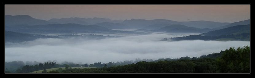
As I gazed out across the hills for today's route the weather, once again, was dry and sunny along with the ever present breeze . Not quite what I've come to expect from Dartmoor - where was the thick mist or driven rain? Not that I was complaining -it made route finding so much easier as I chewed breakfast and used my binos to mentally mark the moorland paths on the ground that connected the clearly defined military tracks I would be using for the first couple of hours today.
Aiming for the Boundary Stone (GR 586 892) I headed onto the military track over Okement Hill (GR 604 875) following it east and up to Hangingstone Hill (GR 617 861)
Along the way, at one of my map/compass/GPS check pauses, I spotted a movement out on the moor. And again. The incongruous sight of a bright orange balloon lifting into the air, and then bobbing back to earth for a time. Pondering the strangeness of the sight I turned to shoulder my pack and realised it was going to be one of those days as this similarly unexpected sight appeared.

We passed the time of day as I discovered the strange unwieldy contraption was part of the guy's hobby of amateur archaeological surveying. What with the charity backpack loads in Princetown earlier in the trip the variety of backpack configurations I'd seen were strange and definitely unexpected.
A reminder that the wilds of Dartmoor may appear to be lonely and inhospitable, but for many they are a familiar place where their own special interests can be followed in a place unique in Southern England.
During the conversation I'd been warned to veer off south-eastwards from the top of Hangingstone Hill as I headed towards White Horse Hill (GR 616 848) Based on my experience of the land I’d been crossing over the last few days, and the general lack of rainfall I decided to try a direct route between the two tops.
Big mistake.
Despite being high atop a ridge the peat hags on this part of the moor were without doubt the worst I encountered anywhere on the trip. Deep, wet and cutting at right angles to the route. In wet or bad weather this area would be extremely difficult, if not dangerous to cross.
Another lesson. Listen to local knowledge.
I continued south until I once again hit the red and white poles indicating the edge of the military area, and turned east along the wall leading to Little Varracombe (GR 625 833)
An idyllic spot beckoned as I easily forded the strongly flowing stream. I paused for a time to take on some lunch, refill water for the long trek ahead, and finally have a Proper Wash in peace and quiet, without, or course, polluting the water supply for any houses in the immediate downstream vicinity. A perfect spot, and in this windless place I was able to sit in the sun and dry off naturally in a 25 deg temperature.
Bliss. A special place that with some simple casting about turned up several potential pitches for the future. Far better that the lonelier (and frankly spooky) Teignhead Farm lower downstream that I’d used in 2008.
 (Sittaford Tor)
After a quick ascent to Sittaford Tor (GR 633 831), and a compass/map check I headed for today's main target (THE GREY WETHERS GR 639 832) using the field boundary wall as a guide.
 (Grey Wethers)
Despite having visited the previous year the strangeness of this place has to be seen to be felt. This time as I descended down to the stones the layout was clear. I had half thought of wildcamping here, but still early afternoon I decided to continue.
From here on it was known territory, moving south along the route down to Postbridge that I’d travelled northwards in June 2008.
This time I didn't make the mistake of descending to the valley path and an inevitable erratic stumbling progress, but stayed high to follow the various cattle tracks alongside the edge of the ridge.
My pace was good and the views down the valley a bonus. Except for an occasional run in with cattle and young calves which seemed determined to group up and then stay in front of me each time I came upon them. A bit of gentle cow talk seemed to persuade them I presented no threat, but with calves around a solo walker can never be too cautious.

Finally to Postbridge Post Office & General Stores. A pack of custard creams and a pint of milk as my reward for the distance covered so far.
Time to work out my next move. Already early evening, and acquainted with the day walker/forestry land nature of the area around Bellever Tor (GR 644 764) there didn’t seem to be much choice but to move onwards.
With a general lack of water sources & a strong likelihood of curious wanderers I decided to head for an old favourite of mine the Forest Inn (GR 655 726) at Hexworthy. Hopefully to stop for a hot meal and a few pints to save on my food and gas.supplies which were starting to run low.
The next section of familiar ground was quite frankly a slog. Forest tracks and road work for the most, and the slow realisation that my feet were beginning to feel sore after today's distance.
Finally. The pub. Closed?
A quarter of an hour to wait for a pint, but an hour an a quarter before food orders were being taken.
At that rate I’d be leaving as dusk was falling. Not a good idea if my planned overnight stop, the old mine workings to the south, were to be reached in daylight. I’d had trouble with this area in the past and these old workings are not the sort of place where you want to stumble around after darkness falls.
Briefly I toyed with the idea of asking for a bed for the night. Not so much the temptation of a shower and warm sheets. Not even, or should that be especially not, the company of other people.
No it was more the thought of hot food, plentiful beer, and a chance to save some of my own fast dwindling supplies. But the wildcamp bug had by now got under my skin. The idea of a 4th consecutive night solo wildcamping had far more appeal. No contest really. So with little real reluctance I finished my pint and departed along the nearby mine track towards the old workings and a good water supply.
The light was starting to wane as I reached it, and I quickly spotted one or two potential pitches. But for some reason the area just didn’t feel right. Nothing specific I could put my finger on, at the time or even now really. It just felt wrong. Perhaps my nights out aloft on the tops had left me with a hemmed in feeling when wildcamping in amongst the broken land.
I moved onwards, climbing higher onto the open moor, increasingly aware of the failing light. A decision justified as I left the shadow of the hillside to meet the sight of the setting sun and truly panoramic view.
A little more exploration, and the tent was pitched near a strongly flowing stream (GR 648 709), food was wolfed down and using the remnants of light reflected from a truly glorious sunset, I disappeared into my sleeping bag for a well needed rest.

I’d been moving since 9am and the 16 miles covered during the day at an average of 2.8 mph had left me tired and foot sore. Sleep was most welcome. But not before the early darkness brought with it the sound of yet another strange nightbird moving around the area. Calling as it flew.
And people think Dartmoor to be lonely and inhospitable.
Not so.
Labels: dartmoor
Comments:
It looks like we only just missed each other, as I was in Postbridge Monday lunchtime, before turning back North.
You can camp at Huccaby Farm 1km North East of the Forest Arms.
Jon
#
posted by  : 26/4/09 8:30 am
Post a Comment
: 26/4/09 8:30 am
Post a Comment
<< Home
As I gazed out across the hills for today's route the weather, once again, was dry and sunny along with the ever present breeze . Not quite what I've come to expect from Dartmoor - where was the thick mist or driven rain? Not that I was complaining -it made route finding so much easier as I chewed breakfast and used my binos to mentally mark the moorland paths on the ground that connected the clearly defined military tracks I would be using for the first couple of hours today.
Aiming for the Boundary Stone (GR 586 892) I headed onto the military track over Okement Hill (GR 604 875) following it east and up to Hangingstone Hill (GR 617 861)
Along the way, at one of my map/compass/GPS check pauses, I spotted a movement out on the moor. And again. The incongruous sight of a bright orange balloon lifting into the air, and then bobbing back to earth for a time. Pondering the strangeness of the sight I turned to shoulder my pack and realised it was going to be one of those days as this similarly unexpected sight appeared.

We passed the time of day as I discovered the strange unwieldy contraption was part of the guy's hobby of amateur archaeological surveying. What with the charity backpack loads in Princetown earlier in the trip the variety of backpack configurations I'd seen were strange and definitely unexpected.
A reminder that the wilds of Dartmoor may appear to be lonely and inhospitable, but for many they are a familiar place where their own special interests can be followed in a place unique in Southern England.
During the conversation I'd been warned to veer off south-eastwards from the top of Hangingstone Hill as I headed towards White Horse Hill (GR 616 848) Based on my experience of the land I’d been crossing over the last few days, and the general lack of rainfall I decided to try a direct route between the two tops.
Big mistake.
Despite being high atop a ridge the peat hags on this part of the moor were without doubt the worst I encountered anywhere on the trip. Deep, wet and cutting at right angles to the route. In wet or bad weather this area would be extremely difficult, if not dangerous to cross.
Another lesson. Listen to local knowledge.
I continued south until I once again hit the red and white poles indicating the edge of the military area, and turned east along the wall leading to Little Varracombe (GR 625 833)
An idyllic spot beckoned as I easily forded the strongly flowing stream. I paused for a time to take on some lunch, refill water for the long trek ahead, and finally have a Proper Wash in peace and quiet, without, or course, polluting the water supply for any houses in the immediate downstream vicinity. A perfect spot, and in this windless place I was able to sit in the sun and dry off naturally in a 25 deg temperature.
Bliss. A special place that with some simple casting about turned up several potential pitches for the future. Far better that the lonelier (and frankly spooky) Teignhead Farm lower downstream that I’d used in 2008.
 (Sittaford Tor)
After a quick ascent to Sittaford Tor (GR 633 831), and a compass/map check I headed for today's main target (THE GREY WETHERS GR 639 832) using the field boundary wall as a guide.
 (Grey Wethers)
Despite having visited the previous year the strangeness of this place has to be seen to be felt. This time as I descended down to the stones the layout was clear. I had half thought of wildcamping here, but still early afternoon I decided to continue.
From here on it was known territory, moving south along the route down to Postbridge that I’d travelled northwards in June 2008.
This time I didn't make the mistake of descending to the valley path and an inevitable erratic stumbling progress, but stayed high to follow the various cattle tracks alongside the edge of the ridge.
My pace was good and the views down the valley a bonus. Except for an occasional run in with cattle and young calves which seemed determined to group up and then stay in front of me each time I came upon them. A bit of gentle cow talk seemed to persuade them I presented no threat, but with calves around a solo walker can never be too cautious.
Finally to Postbridge Post Office & General Stores. A pack of custard creams and a pint of milk as my reward for the distance covered so far.
Time to work out my next move. Already early evening, and acquainted with the day walker/forestry land nature of the area around Bellever Tor (GR 644 764) there didn’t seem to be much choice but to move onwards.
With a general lack of water sources & a strong likelihood of curious wanderers I decided to head for an old favourite of mine the Forest Inn (GR 655 726) at Hexworthy. Hopefully to stop for a hot meal and a few pints to save on my food and gas.supplies which were starting to run low.
The next section of familiar ground was quite frankly a slog. Forest tracks and road work for the most, and the slow realisation that my feet were beginning to feel sore after today's distance.
Finally. The pub. Closed?
A quarter of an hour to wait for a pint, but an hour an a quarter before food orders were being taken.
At that rate I’d be leaving as dusk was falling. Not a good idea if my planned overnight stop, the old mine workings to the south, were to be reached in daylight. I’d had trouble with this area in the past and these old workings are not the sort of place where you want to stumble around after darkness falls.
Briefly I toyed with the idea of asking for a bed for the night. Not so much the temptation of a shower and warm sheets. Not even, or should that be especially not, the company of other people.
No it was more the thought of hot food, plentiful beer, and a chance to save some of my own fast dwindling supplies. But the wildcamp bug had by now got under my skin. The idea of a 4th consecutive night solo wildcamping had far more appeal. No contest really. So with little real reluctance I finished my pint and departed along the nearby mine track towards the old workings and a good water supply.
The light was starting to wane as I reached it, and I quickly spotted one or two potential pitches. But for some reason the area just didn’t feel right. Nothing specific I could put my finger on, at the time or even now really. It just felt wrong. Perhaps my nights out aloft on the tops had left me with a hemmed in feeling when wildcamping in amongst the broken land.
I moved onwards, climbing higher onto the open moor, increasingly aware of the failing light. A decision justified as I left the shadow of the hillside to meet the sight of the setting sun and truly panoramic view.
A little more exploration, and the tent was pitched near a strongly flowing stream (GR 648 709), food was wolfed down and using the remnants of light reflected from a truly glorious sunset, I disappeared into my sleeping bag for a well needed rest.

I’d been moving since 9am and the 16 miles covered during the day at an average of 2.8 mph had left me tired and foot sore. Sleep was most welcome. But not before the early darkness brought with it the sound of yet another strange nightbird moving around the area. Calling as it flew.
And people think Dartmoor to be lonely and inhospitable.
Not so.
Labels: dartmoor
You can camp at Huccaby Farm 1km North East of the Forest Arms.
Jon
: 26/4/09 8:30 am

<< Home
All site material © John Hee - ask before you snatch


