Sunday, February 22
Godshill Wander- Cock, Balls & a Loss

With the spring weather holding and a rare day of free time to myself I took down my walking diaries from the bookshelf earlier this morning to look back over my various trip reports.
I've been keeping a description of all new routes for over fifteen years now. Initially each year had plenty of entries, but as the local variations were ticked off the number of new entries each year has dropped, replaced by infrequent longer reports of wildcamping weeks away.
I've always found it beneficial to keep such a diary. Apart from the smile it brings to my lips as I'm reminded of past journeys, each description ends with a footnote suggesting possibilities for future trips that I've spotted along the way. Over time this has led to uncovering some of my best wildcamping spots, despite the original visit being many years ago.
Today I spotted am idea from the late 1990's - a circular trip using a familiar stretch of the Avon Valley Footpath, north of Fordingbridge, to visit Frankenbury (Grid Ref: OL22/166152), an iron age hill fort.
It's a subject of which I understand only a little, but these old defences are always a worthy reason for a walk as I try to get a taste of why our ancestors chose such places for their homes and lives.
Luckily Dorset and the surrounding areas are extremely rich in ancient hill defences. These vary wildly from the grandiose (Maiden Castle) to the mundane (Buckland Rings) So what would I uncover today?
I crossed the suspended bridge over the River Avon - unique in its construction method in Hampshire I believe.

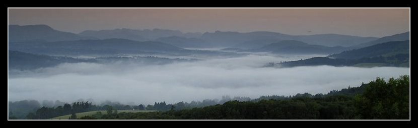
Onto the muddy track across the water meadows and over a number of drainage channels, dotted here and there with their sluice gates. Long ago boats and their cargo travelled along the waterways in this area from the coast inland to Salisbury, 30 miles away. But that was then. Today the remaining ditches remind one more of a fenland scene, were it not for small hills edging along the wide Avon Valley.

Along the way the path forked. To the left ugly recycling bins and agricultural debris. To the right a drop to a track alongside the river and amongst the trees. Beast & beauty? No contest.
Down to the river then. With further reminders of seasonal changes, far more advanced that I would have thought likely at this time of year.
The trees positively dripping with catkins, some the largest I've seen. 

Nearing the hill fort itself a few early primroses in bloom, alongside the stems of bluebells awaiting their turn once the clumps of snowdrops had had their chance.


The path opened onto a forest nature trail, with the inevitable crowds of Sunday strollers. After the natural beauty of the footpath the Nature Trail, composed of ugly 'visitor friendly' tracks & wth the removal of much of the native woodland, was a shock. I quickly cut across this section moving upwards to the hill fort, there to find the remains unhappily now located on agricultural land.
Little remained other than than a small ring defence rampart crowded with hedgerow, tree & briar.
Today it guarded a field of grazing cattle. No sense of history to be found here. This visit, as I've discovered in the past, not so much a reminder of ancient times. More a surprise that such places ever survive at all where modern farming meets ancient remains.
I returned to the nature trail, meeting people oblivious to the historic fortification alongside the man made track as they blindly followed the ugly track, and its clue points -whatever they were.

Needless to say I didn't have my 3 clues by now. Or even any idea what the questions were. But I did have a reason for the human activity as I approached Sandy Balls Holiday Camp, even at this time of year a busy spot.
So instead onto the field footpaths, avoiding the camp. Trying to match the marks on the map to the path on the ground whilst factoring in numerous "Keep Out" & "Private" signs garlanding the trees and hedgerow
Seems like the local landowner & the Camp's visitors may have had their disagreements in the past. But the Godshill area, as I'd noted before from previous visits seems plagued with a need to parcel up land with barb wire defences in the name of horse grazing. And parochial demonstrations of ownership. Its an area where trouser ripping is to be expected as one negotiates the miserly footpaths around the village.
Ah the village. Today that meant the Fighting Cocks Pub for a pint and a pie. It was not to be. The deterrent of Sunday crowds queing for food meant instead I settled for two pints & a Kit-Kat. Dog faring slightly better thanks to abundant dog chews available on the bar for a small charitable donation.
We moved on along Godshill Ridge and onto the open forest. Finally I could leave off the detailed map-to-ground route work and was able to return to my normal practice of pick a point on the horizon and find the least muddy way to it. In this case the unmissable treeline of Godshill Enclosure on the rise above.
West then back to the AVP and a familiar descent back to the valley and my starting point.
Along the way Dog and myself exchanged greetings with a Very Large Bull busily munching its fodder.
I've no idea of the breed, but the maleness of the creature was indisputable as I looked at the enormity of his undercarriage.
A short distance covered, barely 6 miles, but a lengthy wander of 4 hours. A leisurely time for the most, when not bent forward map reading.
But out long enough to breathe deep of the coming changes. And, for a time, enjoy a period of solitary peace amongst the greening shoots of Nature.
Now I wonder how many new visitors to this site will arrive via Google search for Cock or Balls? lolLabels: nature, New Forest, walks
Comments:
Post a Comment
<< Home

With the spring weather holding and a rare day of free time to myself I took down my walking diaries from the bookshelf earlier this morning to look back over my various trip reports.
I've been keeping a description of all new routes for over fifteen years now. Initially each year had plenty of entries, but as the local variations were ticked off the number of new entries each year has dropped, replaced by infrequent longer reports of wildcamping weeks away.
I've always found it beneficial to keep such a diary. Apart from the smile it brings to my lips as I'm reminded of past journeys, each description ends with a footnote suggesting possibilities for future trips that I've spotted along the way. Over time this has led to uncovering some of my best wildcamping spots, despite the original visit being many years ago.
Today I spotted am idea from the late 1990's - a circular trip using a familiar stretch of the Avon Valley Footpath, north of Fordingbridge, to visit Frankenbury (Grid Ref: OL22/166152), an iron age hill fort.
It's a subject of which I understand only a little, but these old defences are always a worthy reason for a walk as I try to get a taste of why our ancestors chose such places for their homes and lives.
Luckily Dorset and the surrounding areas are extremely rich in ancient hill defences. These vary wildly from the grandiose (Maiden Castle) to the mundane (Buckland Rings) So what would I uncover today?
I crossed the suspended bridge over the River Avon - unique in its construction method in Hampshire I believe.
Onto the muddy track across the water meadows and over a number of drainage channels, dotted here and there with their sluice gates. Long ago boats and their cargo travelled along the waterways in this area from the coast inland to Salisbury, 30 miles away. But that was then. Today the remaining ditches remind one more of a fenland scene, were it not for small hills edging along the wide Avon Valley.
Along the way the path forked. To the left ugly recycling bins and agricultural debris. To the right a drop to a track alongside the river and amongst the trees. Beast & beauty? No contest.
Down to the river then. With further reminders of seasonal changes, far more advanced that I would have thought likely at this time of year.
The trees positively dripping with catkins, some the largest I've seen.
Nearing the hill fort itself a few early primroses in bloom, alongside the stems of bluebells awaiting their turn once the clumps of snowdrops had had their chance.
The path opened onto a forest nature trail, with the inevitable crowds of Sunday strollers. After the natural beauty of the footpath the Nature Trail, composed of ugly 'visitor friendly' tracks & wth the removal of much of the native woodland, was a shock. I quickly cut across this section moving upwards to the hill fort, there to find the remains unhappily now located on agricultural land.
Little remained other than than a small ring defence rampart crowded with hedgerow, tree & briar.
Today it guarded a field of grazing cattle. No sense of history to be found here. This visit, as I've discovered in the past, not so much a reminder of ancient times. More a surprise that such places ever survive at all where modern farming meets ancient remains.
I returned to the nature trail, meeting people oblivious to the historic fortification alongside the man made track as they blindly followed the ugly track, and its clue points -whatever they were.
Needless to say I didn't have my 3 clues by now. Or even any idea what the questions were. But I did have a reason for the human activity as I approached Sandy Balls Holiday Camp, even at this time of year a busy spot.
So instead onto the field footpaths, avoiding the camp. Trying to match the marks on the map to the path on the ground whilst factoring in numerous "Keep Out" & "Private" signs garlanding the trees and hedgerow
I've been keeping a description of all new routes for over fifteen years now. Initially each year had plenty of entries, but as the local variations were ticked off the number of new entries each year has dropped, replaced by infrequent longer reports of wildcamping weeks away.
I've always found it beneficial to keep such a diary. Apart from the smile it brings to my lips as I'm reminded of past journeys, each description ends with a footnote suggesting possibilities for future trips that I've spotted along the way. Over time this has led to uncovering some of my best wildcamping spots, despite the original visit being many years ago.
Today I spotted am idea from the late 1990's - a circular trip using a familiar stretch of the Avon Valley Footpath, north of Fordingbridge, to visit Frankenbury (Grid Ref: OL22/166152), an iron age hill fort.
It's a subject of which I understand only a little, but these old defences are always a worthy reason for a walk as I try to get a taste of why our ancestors chose such places for their homes and lives.
Luckily Dorset and the surrounding areas are extremely rich in ancient hill defences. These vary wildly from the grandiose (Maiden Castle) to the mundane (Buckland Rings) So what would I uncover today?
I crossed the suspended bridge over the River Avon - unique in its construction method in Hampshire I believe.

Onto the muddy track across the water meadows and over a number of drainage channels, dotted here and there with their sluice gates. Long ago boats and their cargo travelled along the waterways in this area from the coast inland to Salisbury, 30 miles away. But that was then. Today the remaining ditches remind one more of a fenland scene, were it not for small hills edging along the wide Avon Valley.

Along the way the path forked. To the left ugly recycling bins and agricultural debris. To the right a drop to a track alongside the river and amongst the trees. Beast & beauty? No contest.
Down to the river then. With further reminders of seasonal changes, far more advanced that I would have thought likely at this time of year.
The trees positively dripping with catkins, some the largest I've seen.


Nearing the hill fort itself a few early primroses in bloom, alongside the stems of bluebells awaiting their turn once the clumps of snowdrops had had their chance.


The path opened onto a forest nature trail, with the inevitable crowds of Sunday strollers. After the natural beauty of the footpath the Nature Trail, composed of ugly 'visitor friendly' tracks & wth the removal of much of the native woodland, was a shock. I quickly cut across this section moving upwards to the hill fort, there to find the remains unhappily now located on agricultural land.
Little remained other than than a small ring defence rampart crowded with hedgerow, tree & briar.
Today it guarded a field of grazing cattle. No sense of history to be found here. This visit, as I've discovered in the past, not so much a reminder of ancient times. More a surprise that such places ever survive at all where modern farming meets ancient remains.
I returned to the nature trail, meeting people oblivious to the historic fortification alongside the man made track as they blindly followed the ugly track, and its clue points -whatever they were.

Needless to say I didn't have my 3 clues by now. Or even any idea what the questions were. But I did have a reason for the human activity as I approached Sandy Balls Holiday Camp, even at this time of year a busy spot.
So instead onto the field footpaths, avoiding the camp. Trying to match the marks on the map to the path on the ground whilst factoring in numerous "Keep Out" & "Private" signs garlanding the trees and hedgerow
Seems like the local landowner & the Camp's visitors may have had their disagreements in the past. But the Godshill area, as I'd noted before from previous visits seems plagued with a need to parcel up land with barb wire defences in the name of horse grazing. And parochial demonstrations of ownership. Its an area where trouser ripping is to be expected as one negotiates the miserly footpaths around the village.
Ah the village. Today that meant the Fighting Cocks Pub for a pint and a pie. It was not to be. The deterrent of Sunday crowds queing for food meant instead I settled for two pints & a Kit-Kat. Dog faring slightly better thanks to abundant dog chews available on the bar for a small charitable donation.
We moved on along Godshill Ridge and onto the open forest. Finally I could leave off the detailed map-to-ground route work and was able to return to my normal practice of pick a point on the horizon and find the least muddy way to it. In this case the unmissable treeline of Godshill Enclosure on the rise above.
West then back to the AVP and a familiar descent back to the valley and my starting point.
Along the way Dog and myself exchanged greetings with a Very Large Bull busily munching its fodder.
I've no idea of the breed, but the maleness of the creature was indisputable as I looked at the enormity of his undercarriage.
A short distance covered, barely 6 miles, but a lengthy wander of 4 hours. A leisurely time for the most, when not bent forward map reading.
But out long enough to breathe deep of the coming changes. And, for a time, enjoy a period of solitary peace amongst the greening shoots of Nature.
Now I wonder how many new visitors to this site will arrive via Google search for Cock or Balls? lol
Labels: nature, New Forest, walks

<< Home
All site material © John Hee - ask before you snatch


